Code: 34099630
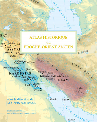
Atlas historique du Proche-Orient ancien
This Historical and Archaeological Atlas of the Ancient Near East brings together accurate and high-quality maps and reports on the latest research findings. It responds to a pressing need for the entire international scientific c ... more
- Language:
 French
 - Binding: Hardback
- Number of pages: 218
Publisher: Les Belles Lettres
- More about this

You might also like
-

Surrender
24 € -29 % -

HISTOIRE DU MITANNI
28.91 € -

NUEVO PRISMA A1 (12 UNIDADES) ED. AMPLIADA - LIBRO DE EJERCICIOS
21.55 € -

Isles of the Gods
17.97 € -19 % -

Woodworking 2022
19.61 € -7 % -

Verissimus
26.76 € -20 % -

Catamaran
21.75 € -

Planning My Blog: Your Ultimate Blog Planning Tool
8.27 € -1 % -

Verity
21.14 € -19 % -

Sea Peoples of the Bronze Age Mediterranean c.1400 BC-1000 BC
15.42 € -28 % -

1000 Flags
19.81 € -24 % -

Ragtime
13.99 € -28 % -

Twisted Games
9.80 € -24 % -

Definitive Guide to Apache Mod_Rewrite
62.22 € -

Autobusy Škoda 706 RO a RTO
11.23 € -22 % -

The Silva Mind Control Method (Pocket)
14.40 € -9 % -

Hellsing Deluxe Volume 3
49.96 € -2 % -

Semantic Mechanisms of Humor
243.69 € -

Ground Zero
9.59 € -18 % -

Capital as Power
59.87 € -

Tearmoon Empire: Volume 1
12.35 € -24 % -

RHS Botanical Art Watercolour Art Pad
15.32 € -18 % -

John Brett
61.40 € -

Nomad Century
23.18 € -19 % -

Alle Vögel singen heute nur für dich
5.41 € -

How I Came to Know Fish
9.80 € -26 % -

Hitorijime my hero
8.78 € -

Critical Role: The Mighty Nein Origins - Fjord Stone
16.85 € -13 % -

The Grandmaster of Demonic Cultivation Light Novel 03
13.17 € -14 % -

War On Heresy
12.46 € -28 % -

Let's Learn Hiragana: First Book Of Basic Japanese Writing
11.43 € -21 % -

Lean Product Playbook - How to Innovate with Minimum Viable Products and Rapid Customer Feedback
27.07 € -29 % -

Wilhelm Tell
4.59 € -

H. J. Heinz Company
26.86 € -19 % -

Story of Life: Evolution (Extended Edition)
13.48 € -28 % -

Data Science
15.11 € -17 % -

Adeste Fideles (O Come, All Ye Faithful) - Sheet Music for Voice and Organ (G Major) - A Christmas Carol
16.85 € -

Bug Club Guided Fiction Year Two White A All at Sea
11.13 € -

Abgeschnitten
18.69 € -

The 48 Laws of Power
24.51 € -10 % -

Finale
16.34 € -

Happy Ever After Playlist
11.13 € -23 %
Give this book as a present today
- Order book and choose Gift Order.
- We will send you book gift voucher at once. You can give it out to anyone.
- Book will be send to donee, nothing more to care about.
Availability alert
Enter your e-mail address and once book will be available,
we will send you a message. It's that simple.
More about Atlas historique du Proche-Orient ancien
You get 171 loyalty points
 Book synopsis
This Historical and Archaeological Atlas of the Ancient Near East brings together accurate and high-quality maps and reports on the latest research findings. It responds to a pressing need for the entire international scientific community working on the pre-classical Near East. The atlas covers the period from the beginning of the Neolithic, around the 10th millennium BC, to the extinction of cuneiform writing at the turn of our era. The geographical area chosen is globally that of the extension of cuneiform writing: from Eastern Anatolia to Western Iran, the Arabian Peninsula and the Gulf. The maps take into account the relief, the variations in the layout of the sides and the course of the rivers. They highlight the boundaries of the different political entities, as well as, in a hierarchical manner, the communication routes and the main cities (the maps of about twenty cities are thus detailed). Each map is accompanied by a short commentary explaining the cartographic choices, the limits of knowledge and the advances in research in the field of historical geography over the last twenty years. After the map book, a chapter brings together the sources and a selection of the most up-to-date bibliographical references for each contribution. In addition, there is a geographical index listing the modern and ancient names of the sites and their different variants, as well as an index of proper names. In total, the project, directed by Martin Sauvage, an archaeological research engineer at the CNRS, brings together some fifty contributors: university lecturers in France and abroad, CNRS researchers and engineers, students and post-doctoral students, mainly attached to three teams of the UMR (Unité mixte de recherche) ArScAn but also to 5 other UMRs in France and 5 universities abroad.
 Book details
Book category Books in French CARTES GÉOGRAPHIQUES ET ATLAS
69.17 €
- Full title: Atlas historique du Proche-Orient ancien
- Language:
 French
 - Binding: Hardback
- Number of pages: 218
- EAN: 9782251451138
- ID: 34099630
- Publisher: Les Belles Lettres
- Weight: 2052 g
- Dimensions: 383 × 306 × 18 mm
Trending among others
-

GLOBE 25 CM BLEU ENFANT ILLUSTRE
45.66 € -

Atlas des vignobles de Bourgogne
9.90 € -

Atlas militaire et stratégique
34.02 € -

Grand Atlas 2024
28.50 € -

Atlas mondial des littoraux
34.02 € -

Atlas géopolitique d'Israël
22.88 € -14 % -

GLOBE RETRO 18 CM ANTIQUE PIED LAITON
45.66 € -

ATLAS DE LA FRANCE
10.11 € -

Atlas historique de la France
9.08 € -

Atlas des vignobles de France
14.81 € -

L'atlas des atlas
45.77 € -

Atlas Mondial
12.35 € -

GLOBE 30 CM INCLINE NOIR CARTO
76.42 € -

Atlas de l'histoire de France
14.81 € -

Atlas des 197 Etats du monde
14.81 € -

Atlas historique du monde biblique
44.64 € -

GLOBE 14 CM NOIR ET OR LUMINEUX SUPPORT BOIS
35.86 € -

GLOBE 30 CM NOIR LUMINEUX PIED DORE/NOIR
104.83 € -

GLOBE 14 CM BLEU LUMINEUX + SUPPORT EN BOIS
35.86 € -

Voyage de l'Arctique à la Terre de Feu, Un atlas de l'Amérique
28.29 € -
Régions à la découpe
24.82 € -

Atlas de l'Alsace - Enjeux et émergences
31.87 € -

L'Atlas historique de l'Algérie
45.87 € -

ATLAS DE L'ESPAGNE
30.64 € -

ATLAS HISTORIQUE DE L'AFRIQUE
30.64 € -

Atlas des glaciers
30.64 € -

L'Atlas des frontières (nouvelle édition)
34.12 € -

GLOBE RETRO 18 CM NOIR PIED LAITON
45.66 € -

GLOBE 14 CM ANTIQUE LUMINEUX + SUPPORT EN BOIS
35.86 € -

La France en perspective
31.87 € -

Atlas de la France dans la Seconde Guerre mondiale
30.64 € -

GLOBE 25 CM BLEU LUMINEUX POLITIQUE
49.34 € -

Atlas historique de la Russie
30.64 € -

Love History
24.82 € -

Atlas du moyen-orient
31.87 € -

Atlas mondial junior
14.81 € -

Atlas de la France, l'essentiel en 40 cartes
9.39 € -

Atlas des chemins de Compostelle
14.81 € -

ATLAS VISUO TACTILE REGION MIDI PYRENEES
25.94 € -

Les 20 plus belles cartes du monde
35.24 € -

Atlas de la Chine
34.02 € -

Atlas des mobilités et des transports
34.02 € -

Atlas de l'agriculture
34.02 € -

Atlas de la biodiversité
30.64 € -

Le Blanc des cartes
36.47 € -

Atlas des Etats-unis, les paradoxes de la puissance
20.12 € -

Atlas des montagnes
30.64 € -

ATLAS DES RELIGIONS - PASSIONS IDENTITAIRES ET TENSIONS GEOPOLITIQUES
34.02 € -

Atlas du Moyen-Orient
34.02 €
Collection points Bratislava a 2642 dalších
Copyright ©2008-24 najlacnejsie-knihy.sk All rights reservedPrivacyCookies


 15549 collection points
 Delivery 2.99 €
 02/210 210 99 (8-15.30h)