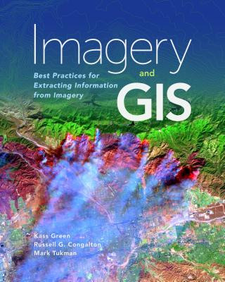
Code: 14224732
Imagery and GIS
by Kass Green, Russell G. Congalton, Mark Tukman
Today, most maps include imagery in the form of aerial photos, satellite images, thermal images, digital elevation models, and scanned maps. Imagery and GIS: Best Practices for Extracting Information from Imagery shows how imagery ... more
- Language:
 English
 - Binding: Paperback
- Number of pages: 418
Publisher: ESRI Press, 2017
- More about this

134.78 €

Low in stock at our supplier
Shipping in 10 - 15 days
Potřebujete více kusů?Máte-li zájem o více kusů, prověřte, prosím, nejprve dostupnost titulu na naši zákaznické podpoře.
Add to wishlist
You might also like
-
GIS for Science
53.23 € -

Esri Guide to GIS Analysis, Volume 1
68.26 € -

Reconstruction and Analysis of 3D Scenes
207.37 € -

LiDAR Remote Sensing and Applications
136.01 € -
GIS Tutorial for ArcGIS Desktop 10.8
134.47 € -

Thematic Mapping
79.17 € -

Our Babies, Ourselves
19.35 € -6 % -

Making a Difference in Theory
89.88 € -

Horace: Odes II: Vatis Amici
120.05 € -

Believing Again
29.65 € -4 % -

Mannequins' Ball
230.03 € -

Overcoming Underearning
15.85 € -23 % -

Smart Contracts and Comparative Law
178.13 € -

Jak přežít léčení
10.70 € -20 %
Give this book as a present today
- Order book and choose Gift Order.
- We will send you book gift voucher at once. You can give it out to anyone.
- Book will be send to donee, nothing more to care about.
More about Imagery and GIS
You get 331 loyalty points
 Book synopsis
Today, most maps include imagery in the form of aerial photos, satellite images, thermal images, digital elevation models, and scanned maps. Imagery and GIS: Best Practices for Extracting Information from Imagery shows how imagery can be integrated successfully into GIS maps and analysis.
 Book details
Book category Books in English Earth sciences, geography, environment, planning Geography Geographical information systems (GIS) & remote sensing
134.78 €
- Full title: Imagery and GIS
- Subtitle: Best Practices for Extracting Information from Imagery
- Author: Kass Green, Russell G. Congalton, Mark Tukman
- Language:
 English
 - Binding: Paperback
- Number of pages: 418
- EAN: 9781589484542
- ISBN: 1589484541
- ID: 14224732
- Publisher: ESRI Press
- Weight: 1178 g
- Dimensions: 254 × 203 × 30 mm
- Date of publishing: 30. November 2017
Trending among others
-

Cartography.
77.01 € -

Designing Better Maps
70.52 € -4 % -

Semiology of Graphics
145.80 € -

Geographic Information Science and Systems 4e
226.52 € -5 % -
GIS for Science
53.33 € -
Geocaching
20.58 € -3 % -

Mastering Geospatial Analysis with Python
66.41 € -

Connections and Content
54.26 € -

Introduction to Geographical Information Systems, An
99.97 € -
Esri Guide to GIS Analysis, Volume 3
61.67 € -

Focus on Geodatabases in ArcGIS Pro
79.17 € -

Springer Handbook of Geographic Information
448.94 € -

Framework for Geodesign
105.02 € -

Geoinformatics
39.43 € -

Mastering ArcGIS Server Development with JavaScript
59.40 € -

GIS For Dummies
40.35 € -

ArcGIS Book
32.12 € -

Python For ArcGIS
153 € -

Spring Boot Messaging
58.58 € -
GNSS - Global Navigation Satellite Systems
253.61 € -

ArcGIS Pro and ArcGIS Online Applications in Water and Environmental Sciences
91.94 € -

GIS in Land and Property Management
333.92 € -

Programming GPS and OpenStreetMap Applications with Java
94 € -

GIS and Spatial Analysis for the Social Sciences
132.92 € -

Spatial Statistics and Geostatistics
90.30 € -

European Landscape Dynamics
273.07 € -

Introducing Geographic Information Systems with ArcGIS - A Workbook Approach to Learning GIS, Third Edition
141.68 € -

QGIS Python Programming Cookbook -
66.41 € -

Artificial Intelligence in Geography
389.12 € -

GPS For Dummies 2e
27.28 € -3 % -

Introduction to GIS Programming and Fundamentals with Python and ArcGIS (R)
155.17 € -

Satellite Interferometry Data Interpretation and Exploitation
195.84 € -

Learning ArcGIS Pro
66.41 € -

Mastering QGIS -
73.51 € -

Error Propagation in Environmental Modelling with GIS
167.93 € -

Integration of GIS and Remote Sensing
292.63 € -

Interacting with Geospatial Technologies
175.97 € -

Energy of Nations
56.73 € -

Open Source GIS
215.82 € -
High Performance Computing and the Art of Parallel Programming
417.02 € -

Thermal Infrared Remote Sensing
227.14 € -

Physical Principles of Remote Sensing
221.58 € -

Latest Developments in Geographic Information Systems: Volume I
163.20 € -

Remote Sensing and GIS Integration: Theories, Methods, and Applications
229.20 € -
Metrics That Make a Difference
158.77 € -

Applications of Remote Sensing and GIS Based on an Innovative Vision
257.31 € -

Mapping with ArcGIS Pro
59.40 € -

Satellite Altimetry Over Oceans and Land Surfaces
308.39 € -

Learning QGIS 2.0
33.46 €
Collection points Bratislava a 2642 dalších
Copyright ©2008-24 najlacnejsie-knihy.sk All rights reservedPrivacyCookies


 15549 collection points
 Delivery 2.99 €
 02/210 210 99 (8-15.30h)