Code: 53244871
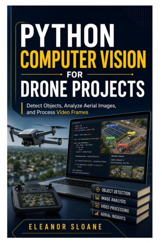
Python Computer Vision for Drone Projects
by Eleanor Sloane
Transform Drone Photos and Videos into Useful Visual Data with PythonDrone flights can produce hundreds of aerial photographs and thousands of video frames. Reviewing every file manually is slow, inconsistent, and often overwhelmi ... more


- Language:
 English
 - Binding: Paperback
- Number of pages: 222
Publisher: Independently published, 2026
- More about this

18.39 €
RRP: 20.45 €
You save 2.06 €

You might also like
-
Moonwalk
14.05 € -18 % -

The Score
12.43 € -8 % -

Berserk Deluxe Volume 1
35.89 € -25 % -

The Deal
12.33 € -9 % -

The Mistake
11.32 € -28 % -

Jujutsu Kaisen, Vol. 30
9.70 € -25 % -

Berserk Deluxe Volume 2
36.29 € -31 % -

Dancing The Dream
19.91 € -31 % -

Murdoku
14.65 € -22 % -

Berserk Deluxe Volume 3
55.40 € -

White Nights
4.54 € -14 % -

The Goal
12.93 € -4 % -
Threshing Day (Wing and Claw Collection)
17.79 € -29 % -
Invincible Compendium Volume 2
45.80 € -24 % -

Chainsaw Man, Vol. 21
9.90 € -20 % -

The Legacy
11.92 € -12 % -

Jujutsu Kaisen, Vol. 29
7.67 € -30 % -
Invincible Compendium Volume 3
45.80 € -24 % -

Lord of Mysteries, Vol. 3: The Clown, Part III
17.08 € -13 % -

Berserk Deluxe Volume 5
55 € -

Jujutsu Kaisen, Vol. 26
9.90 € -20 %
Give this book as a present today
- Order book and choose Gift Order.
- We will send you book gift voucher at once. You can give it out to anyone.
- Book will be send to donee, nothing more to care about.
Availability alert
Enter your e-mail address and once book will be available,
we will send you a message. It's that simple.
More about Python Computer Vision for Drone Projects
You get 45 loyalty points
 Book synopsis
Transform Drone Photos and Videos into Useful Visual Data with Python
Drone flights can produce hundreds of aerial photographs and thousands of video frames. Reviewing every file manually is slow, inconsistent, and often overwhelming. With computer vision, you can automate parts of the process, identify visible features, detect objects, analyse movement, measure coverage, and produce organised results for inspection, mapping, agriculture, construction, and research projects.
Python Computer Vision for Drone Projects is a practical, beginner-friendly guide to processing aerial images and videos with Python. Rather than overwhelming you with mathematical theory, it teaches computer vision through clear explanations, working scripts, troubleshooting guidance, and realistic drone-related projects.
You will begin by creating a clean Python workspace before learning how digital images, pixels, colour channels, metadata, resolution, and video frames work. From there, you will progress through image enhancement, edge detection, motion analysis, object detection, custom model training, geospatial data, measurement, and automated reporting.
Inside this hands-on guide, you will learn how to:
- Set up an isolated Python computer-vision workspace
- Organise source photographs, videos, scripts, outputs, and results
- Load, display, crop, resize, convert, and save aerial images
- Protect original drone files while creating processed copies
- Understand RGB, BGR, grayscale, alpha channels, pixels, and resolution
- Read drone-image metadata and recognise its limitations
- Improve brightness, contrast, sharpness, and low-contrast imagery
- Reduce noise without destroying useful visual detail
- Apply thresholding, Canny edge detection, and contour analysis
- Identify visible rooflines, roads, field boundaries, and land features
- Read drone video files frame by frame
- Extract useful still images from long inspection footage
- Split image data into training, validation, and testing groups
- Train and evaluate a small custom object detector
- Read GeoTIFF files using Python
- Work with coordinates, raster data, masks, and geospatial layers
- Estimate visual coverage and approximate areas responsibly
- Export counts, measurements, and detection results to CSV
- Batch-process multiple images with a repeatable workflow
- Generate processed images, tables, charts, and project summaries
Practical projects include an aerial-image viewer, field-boundary detector, video-frame extractor, movement detector, aerial vehicle detector, custom training dataset, GeoTIFF inspector, automated image-analysis report generator, and a complete integrated drone-vision workflow.
The book uses practical tools such as OpenCV, NumPy, Matplotlib, Pillow, Ultralytics YOLO, Rasterio, and GeoPandas. Each project includes a defined objective, setup instructions, implementation steps, testing procedures, expected results, and troubleshooting guidance.
Whether you are a drone pilot, student, inspection professional, agricultural worker, survey assistant, mapping technician, researcher, hobbyist, or developer, this guide will help you move beyond simply collecting aerial imagery.
Process the footage. Detect useful features. Validate the results. Turn aerial data into information people can review and use.
Book details
18.39 €
- Full title: Python Computer Vision for Drone Projects
- Subtitle: Detect Objects, Analyze Aerial Images, and Process Video Frames
- Author: Eleanor Sloane
- Language: English
- Binding: Paperback
- Number of pages: 222
- EAN: 9798187421398
- ID: 53244871
- Publisher: Independently published
- Weight: 276 g
- Dimensions: 229 × 152 × 14 mm
- Date of publishing: 15. July 2026
Osobný odber Bratislava a 12833 dalších
Copyright ©2008-26 najlacnejsie-knihy.sk Všetky práva vyhradenéSúkromieCookies

 24 miliónov titulov
 Vrátenie do mesiaca
 02/210 210 99 (8-15.30h)