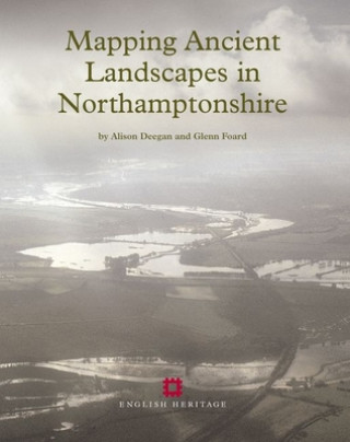
Kód: 05025685
Mapping Ancient Landscapes in Northamptonshire
Autor Alison Deegan, Glenn Foard
Aerial reconnaissance and the National Mapping Programme project in Northamptonshire have recovered and mapped evidence of archaeological activity of widely varying character, from field systems through settlement remains to funer ... celý popis
- Jazyk:
 Angličtina
 - Väzba: Brožovaná
- Počet strán: 180
Nakladateľ: Historic England, 2007
- Viac informácií o knihe

105.39 €

Skladom u dodávateľa v malom množstve
Odosielame za 12 - 17 dní
Potrebujete viac kusov?Ak máte záujem o viac kusov, preverte, prosím, najprv dostupnosť titulu na našej zákazníckej podpore.
Pridať medzi želanie
Mohlo by sa vám tiež páčiť
-

Hero Dogs: Secret Missions and Selfless Service
24.06 € -

Crisis of Imagination
76.30 € -

THE MURDER OF ROGER ACKROYD+CD
8.90 € -19 % -

National Front & French Pol Pb
40.86 € -

Primal Blueprint
22.01 € -23 % -
W.B. Yeats Chronology
139.60 € -

Cinema of Contradiction
127.62 € -4 %
Darujte túto knihu ešte dnes
- Objednajte knihu a vyberte Zaslať ako darček.
- Obratom obdržíte darovací poukaz na knihu, ktorý môžete ihneď odovzdať obdarovanému.
- Knihu zašleme na adresu obdarovaného, o nič sa nestaráte.
Viac informácií o knihe Mapping Ancient Landscapes in Northamptonshire
Nákupom získate 260 bodov
 Anotácia knihy
Aerial reconnaissance and the National Mapping Programme project in Northamptonshire have recovered and mapped evidence of archaeological activity of widely varying character, from field systems through settlement remains to funerary monuments, and ranging in period from the Neolithic to the 20th century. This volume presents research and analyses the project's results. The introduction is followed by two chapters that consider the reasons for the biases in the distribution of aerial photographic evidence. The first of these chapters reviews the history of aerial reconnaissance and mapping in Northamptonshire. The second considers the impact of soils, geology and past and present land use on the survival and visibility of earthworks, crop marks and soil marks. The subsequent analyses of the project's results are presented primarily by period. First there is a discussion of the monuments and landscapes of the Neolithic and Bronze Age in the context of results from archaeological excavations, and in particular from the Raunds Area Project. This is followed by a review of the wider evidence for these periods in Northamptonshire and the Midlands by Alex Gibson. Reflecting the wealth of information revealed by aerial archaeology for these periods, a large proportion of this volume in concentrated on the Iron Age and Roman periods, in an attempt to characterise the settlements, boundaries and communications across different landscape zones. The three chapters on the Anglo-Saxon, medieval and post-medieval landscapes, and on 20th-century military remains review the contribution of the aerial archaeological evidence and consider whether this was maximised by the project. The final chapter assesses the methodology that evolved during the course of the project and its impact on data creation and subsequent data manipulation, interrogation and dissemination. The Northamptonshire National Mapping Programme data is archived by and disseminated through the National Monuments Record, Northamptonshire Sites and Monuments Record and also the Archaeology Data Service, York.
 Parametre knihy
Zaradenie knihy Knihy po anglicky The arts Photography & photographs Special kinds of photography
105.39 €
- Celý názov: Mapping Ancient Landscapes in Northamptonshire
- Autor: Alison Deegan, Glenn Foard
- Jazyk:
 Angličtina
 - Väzba: Brožovaná
- Počet strán: 180
- EAN: 9781905624423
- ISBN: 1905624425
- ID: 05025685
- Nakladateľ: Historic England
- Hmotnosť: 530 g
- Rozmery: 274 × 218 × 12 mm
- Dátum vydania: 31. December 2007
Obľúbené z iného súdka
-

In the Blink of An Eye
17.50 € -

Filmmaker's Eye
41.27 € -

Five C's of Cinematography
31.64 € -

Wes Anderson Collection: The Grand Budapest Hotel
31.13 € -16 % -

Sound Design
22.83 € -18 % -

Ballet for Everybody
26.21 € -2 % -

Underwater Photographer
52.64 € -

Master Shots
27.54 € -17 % -

Master Shots, Vol 2
27.65 € -18 % -

Hubble's Universe: 2nd Ed; Greatest Discoveries and Latest Images
33.38 € -18 % -
Film Directing Cinematic Motion
27.44 € -23 % -

Filmmaker's Eye: The Language of the Lens
44.55 € -
Cameraless Photography
30.21 € -16 % -

Cut to the Chase
17.20 € -14 % -

Handcoloring Photographs
34.61 € -

Eye is Quicker
23.65 € -18 % -

Master Shots, Vol. 3
37.38 € -

Polaroid Book
26.11 € -

Expanding Universe. Photographs from the Hubble Space Telescope
61.24 € -

Video Art
21.91 € -23 % -

You Are Here
18.73 € -23 % -

How to Shoot Video That Doesnt Suck
14.53 € -21 % -

Masters of Landscape Photography
30.21 € -16 % -

Street Photography
25.29 € -18 % -

Digital Compositing for Film and Video
80.81 € -
Astrophotography Manual
68.10 € -

Retro Cameras
31.44 € -

Earth from the Air - 365 New Days
29.69 € -16 % -

Filmmaker's Guide to Visual Effects
45.67 € -
Dialogue Editing for Motion Pictures
66.57 € -

Art and Technique of Digital Color Correction
91.97 € -

Expressive Nature Photography
24.78 € -13 % -
Digital SLR Astrophotography
43.21 € -4 % -

Stargazing
35.63 € -2 % -

Escape
38.20 € -23 % -

Setting Up Your Shots
32.36 € -

Cracking Animation
39.42 € -4 % -

Cinematography
26.72 € -6 % -

Camera Assistant
255.96 € -

Behind the Lens
67.59 € -10 % -

Picture Perfect Lighting
41.27 € -19 % -

Infinite Wonder
23.55 € -17 % -

LA NY
25.29 € -18 % -

Motion Graphics
42.91 € -7 % -

Introduction to Cinematography
70.87 € -

Color and Mastering for Digital Cinema
119.83 € -

Film Editing
27.44 € -23 % -

Understanding Cinematography
20.78 € -14 % -

Cinematographer Style - The Complete Interviews, Volume I
36.76 €
Osobný odber Bratislava a 2642 dalších
Copyright ©2008-24 najlacnejsie-knihy.sk Všetky práva vyhradenéSúkromieCookies


 21 miliónov titulov
 Vrátenie do mesiaca
 02/210 210 99 (8-15.30h)