Kód: 04353670
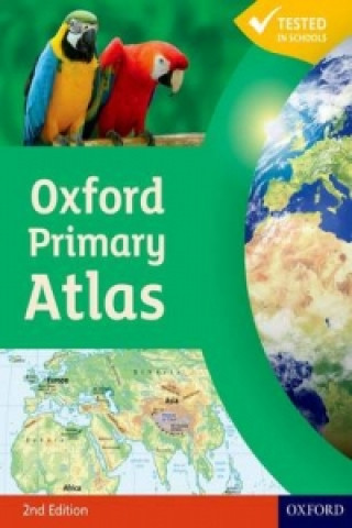
Oxford Primary Atlas
Autor Patrick Wiegland
The Oxford Primary Atlas is a clear, bright and informative atlas for all 7-11 year olds. This new edition includes up-to-date country data and easy-to-read colourful mapping, presented in an accessible visual layout based on rese ... celý popis
- Jazyk:
 Angličtina
 - Väzba: Brožovaná
- Počet strán: 88
Nakladateľ: Oxford University Press, 2011
- Viac informácií o knihe

13.56 €
Bežne: 15.66 €
Ušetríte 2.09 €

Skladom u dodávateľa
Odosielame za 3 - 5 dní
Mohlo by sa vám tiež páčiť
-

Oxford International Primary Atlas
12.06 € -22 % -

Oxford International First Atlas (2011)
12.26 € -10 % -

Oxford International Student's Atlas
17.89 € -23 % -

Earlier Tudors 1485-1558
286.78 € -

Oxford Student Atlas 2012
17.29 € -23 % -
Oxford Primary Atlas Activity Book
13.56 € -

Oxford First Atlas
12.36 € -13 % -
Fairyland 2 Activity Book
20.40 € -9 % -

Design and Digital Interfaces
39.81 € -5 % -

Big Book of the UK
16.28 € -23 % -

design psychology
19.27 € -

henhouse
21.81 € -

Questions and Admissions
141.17 € -

Rangers 1923 to 1934: Eleven Great Years
22.72 € -5 % -

Secrets of Staying Young
28.65 € -

Jolly Christmas Postman
14.57 € -12 % -

Best Word Book Ever
9.44 € -20 % -

100 All-Time Favorite Movies
53.18 € -

Naruto, Vol. 31
10.05 € -12 % -

Uncle Andy's Cats
17.39 € -12 % -

Big Book of English Words
10.65 € -20 %
Darujte túto knihu ešte dnes
- Objednajte knihu a vyberte Zaslať ako darček.
- Obratom obdržíte darovací poukaz na knihu, ktorý môžete ihneď odovzdať obdarovanému.
- Knihu zašleme na adresu obdarovaného, o nič sa nestaráte.
Viac informácií o knihe Oxford Primary Atlas
Nákupom získate 34 bodov
 Anotácia knihy
The Oxford Primary Atlas is a clear, bright and informative atlas for all 7-11 year olds. This new edition includes up-to-date country data and easy-to-read colourful mapping, presented in an accessible visual layout based on research into how young children use maps. It features key curriculum themes such as landscapes, water, settlements, connections, and environments. It includes easy-to-use features such as learning statements to summarize each theme, focus panels to prompt independent or group enquiry, innovative grid codes to help children find places listed in the index, colourful photographs to aid children's understanding of map symbols, attractive artwork to provide a 'sense of place', and stimulating graphics to make large numbers easy to understand. This new edition of the Oxford Primary Atlas, specially written to support the requirements of primary geography at Key Stage 2, and incorporating the most popular features of the bestselling Oxford Junior Atlas, uses simple, clear mapping and colourful illustration to create a stimulating and informative atlas for all 7-11 year olds. The Oxford Primary Atlas is also accompanied by the Activity Book for independent work to develop map literacy skills, and the e-Atlas CD-ROM for whole class display on interactive whiteboard.
 Parametre knihy
Zaradenie knihy Knihy po anglicky Children's, Teenage & educational Reference material (Children's / Teenage) Atlases & maps (Children’s/Teenage)
13.56 €
- Celý názov: Oxford Primary Atlas
- Autor: Patrick Wiegland
- Jazyk:
 Angličtina
 - Väzba: Brožovaná
- Počet strán: 88
- EAN: 9780198480174
- ISBN: 0198480172
- ID: 04353670
- Nakladateľ: Oxford University Press
- Hmotnosť: 308 g
- Rozmery: 289 × 222 × 5 mm
- Dátum vydania: 03. March 2011
Obľúbené z iného súdka
-

50 States
21.61 € -23 % -

Big Picture Atlas
16.28 € -23 % -
National Geographic Kids U.S. Atlas 2020
13.16 € -6 % -
Maps
24.93 € -19 % -
Maps Poster Book
14.17 € -23 % -
Philip's Modern School Atlas
19.70 € -
Maps Activity Book
10.95 € -23 % -

Children's Picture Atlas
10.95 € -23 % -

National Geographic Kids Ultimate Globetrotting World Atlas
12.36 € -13 % -

Oxford School Atlas
13.06 € -23 % -

Travel Book
30.96 € -

Oxford Student Atlas
17.29 € -23 % -

Oxford School Atlas
14.17 € -23 % -
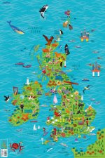
Children's Wall Map of the United Kingdom and Ireland
7.53 € -13 % -

Oxford Very First Atlas
7.73 € -23 % -

Usborne Illustrated Atlas of Britain and Ireland
16.28 € -23 % -
National Geographic Kids World Atlas
22.01 € -13 % -
Maps Special Edition
43.73 € -

Barefoot Books World Atlas
16.28 € -23 % -

Oxford International First Atlas Activity Book
7.83 € -

Children's Illustrated World Atlas
16.28 € -23 % -

National Geographic Student World Atlas Fourth Edition
11.65 € -

National Geographic Kids Beginner's World Atlas, 3rd Edition
14.47 € -
C48 First Atlas Book
12.76 € -37 % -

Atlas of the World Picture Book
14.47 € -
Washington DC Children's Map
5.72 € -4 % -

Guy Fox Maps for Children
5.72 € -4 % -

First Animal Picture Atlas
14.17 € -23 % -
Map of Europe
24.02 € -5 % -

World Atlas
16.88 € -

My Pop-up World Atlas
21.31 € -

Our World
16.18 € -
First Atlas
18.89 € -

Atlas of Ocean Adventures
24.43 € -13 % -

Lonely Planet Kids My Family Travel Map - Europe
21.01 € -
National Geographic Kids U.S. Atlas 2020
20.81 € -
Beginner's U.S. Atlas 2020
15.98 € -13 % -

Picture Atlas
7.53 € -13 % -
Collins Student Atlas
23.02 € -

Lonely Planet Kids Amazing World Atlas
18.39 € -13 % -

Illustrated Atlas of India
24.83 € -

Children's World Atlas
18.89 € -

The Kingfisher Atlas of World History
28.05 € -

National Geographic Little Kids First Big Book of the World
35.18 € -

First Picture Atlas
13.26 € -
Mapping Skills
23.22 € -
Mapping Skills
23.22 € -
Children's Illustrated Atlas (Library Edition)
22.41 € -

Collins Keystart Junior Atlas CD-Rom
175.86 €
Osobný odber Bratislava a 2642 dalších
Copyright ©2008-24 najlacnejsie-knihy.sk Všetky práva vyhradenéSúkromieCookies


 21 miliónov titulov
 Vrátenie do mesiaca
 02/210 210 99 (8-15.30h)